heat wave

Early heat wave breaks records, causes deaths across Europe
An unusually early heat wave has swept across parts of Western Europe, breaking long-standing temperature records and causing several deaths, officials said.
In the United Kingdom, temperatures crossed 35 degrees Celsius on Tuesday, setting a new record for this time of year for the second day in a row. According to the Met Office, 35.1°C was recorded at London’s Kew Gardens, surpassing both Monday’s record and a century-old high set in 1922.
London also experienced a rare “tropical night,” where temperatures stayed above 20°C.
France has also been hit by extreme heat, with temperatures reaching up to 36°C in the southwest and remaining above 20°C overnight in many areas. The country’s weather agency said a “heat dome” — a high-pressure system trapping hot air — is pushing temperatures more than 10°C above normal for this time of year.
Experts say such extreme and unpredictable weather events are becoming more common due to climate change. They warn that rising global temperatures are making heat waves more frequent and intense, even in seasons when they are not usually expected.
After a long weekend, many people in the UK crowded beaches and parks to cool down, while commuters struggled in overheated trains and subways without air conditioning. Some train services were disrupted due to heat-related issues.
Emergency services also responded to wildfires in parts of Scotland, where a large grass fire broke out near Edinburgh.
Health authorities in the UK have issued an amber alert, warning of possible health risks, especially for older people. Since many homes and public places in the country lack air conditioning, the heat has become particularly challenging.
At least five people, including teenagers, have died in the UK in suspected drowning incidents as they tried to cool off in lakes and reservoirs.
In France, officials reported at least seven deaths linked to the heat, including several drownings and fatalities during sports activities. The risks have increased as the heat wave arrived before lifeguards were deployed at many beaches.
Authorities have urged people to be cautious, especially along the Atlantic coast, where strong currents have already led to multiple rescue incidents.
The heat has also spread to Spain, where temperatures in some areas have reached up to 38°C levels usually seen in mid-summer. Weather officials say temperatures across the region are 5 to 10°C higher than normal.
In Italy, Rome is also experiencing rising temperatures, with highs expected to reach around 32°C.
Officials across Europe are continuing to warn people to stay safe as the unusual heat wave continues.
24 days ago

Rain, thunderstorms likely in parts of country; heat wave may ease
Bangladesh Meteorological Department(BMD) predicted light to moderate rains in parts of the country including Rangpur, Mymensingh and Sylhet divisions in 24 hours from 9am on Sunday.
“Rains or thunder showers accompanied by temporary gusty or squally wind and lightning flashes are likely over Rangpur, Mymensingh & Sylhet divisions and at one or two places over Rajshahi, Dhaka, Khulna, Barishal & Chattogram divisions with moderately heavy to very heavy falls at places over Rangpur, Mymensingh and Sylhet divisions,”said a Met office bulletin.
Besides, the mild heat wave sweeping over Khulna division and Dhaka, Madaripur, Rajshahi, Pabna, Patuakhali, Rangamati, Bandarban, Chandpur, Laxmipur & Feni districts may abate from some places.
Day temperature may fall by (1-2)°C over Rangpur, Rajshahi, Dhaka, Mymensingh & Sylhet divisions and it may fall slightly elsewhere over the country.
Night temperature may fall slightly over the country.
1 month ago

Mild to moderate heat wave sweeps Dhaka, other parts of country: Met office
A mild to moderate heat wave is sweeping over different parts of the country including Dhaka and it may continue, Bangladesh Meteorological Department (BMD) said on Saturday.
“A mild to moderate heat wave is sweeping over Rajshahi and Khulna divisions and the districts of Dhaka, Faridpur, Gopalganj, Manikganj, Narayanganj, Rangamati, Chandpur, Barishal, Patuakhali and it may continue,” said a Met office bulletin.
Besides, rain or thundershowers accompanied by temporary gusty wind and lightning flashes is likely to occur at one or two places over Chattogram and Sylhet divisions, it said.
Weather may remain mainly dry with temporary partly cloudy sky elsewhere over the country.
Day and night temperatures may remain nearly unchanged over the country.
The highest temperature of 39.7°C was recorded in Chuadanga on Friday.
A trough of low lies over West Bengal and adjoining area. Seasonal low lies over South Bay.
2 months ago

Mild to moderate heat wave grips parts of country
A mild to moderate heat wave is sweeping across several parts of the country and may expand further, according to a bulletin issued by the Bangladesh Meteorological Department (BMD) on Friday morning.
The heat wave is currently affecting Rajshahi and Khulna divisions, along with the districts of Tangail, Faridpur, Manikganj and Nilphamari, it said.
The highest temperature of 38.5°C was recorded in Chuadanga on Thursday.
Meanwhile, rain or thundershowers accompanied by temporary gusty winds and lightning are likely at one or two places over Sylhet division in the 24 hours commencing at 9am on Friday.
Elsewhere, the weather is expected to remain mainly dry with partly cloudy skies at times. Day and night temperatures may rise slightly across the country.
The bulletin added that a trough of low pressure lies over West Bengal and adjoining areas, while a seasonal low lies over the South Bay.
2 months ago

Heat wave may sweep Bangladesh during Eid celebrations
People in parts of Bangladesh may have to endure extreme heat rather than comfort during tomorrow’s Eid-ul-Fitr celebrations.
“Mild to moderate heat wave is sweeping over Dhaka, Rajshahi and Khulna divisions and Moulvibazar, Rangamati, Barishal & Patukhali districts and it may abate some places,” said a Met office bulletin on Sunday.
Heatwave affects Dhaka, other divisions; temperatures expected to rise
Weather may remain dry with temporary partly cloudy sky over the country, it said.
Day temperature may fall slightly and night temperature may rise slightly over the country.
Country’s highest temperature was recoded at 37.2 Degree Celsius in Ishwardi upazila of Pabna.
1 year ago

No relief in sight during Eid as heat wave continues
The Bangladesh Meteorological Department (BMD) has forecast that the severe to moderate heatwave sweeping over Dhaka and several other districts will continue until Eid-ul-Fitr.
The heat wave situation is expected to remain unchanged for five days, said a BMD bulletin on Saturday
“A severe heat wave is sweeping over Jashore and Sirajganj. A mild to moderate heat wave is sweeping over Dhaka and Barishal, parts of Rajshahi, Khulna, Moulvibazar, Brahmanbaria and Rangamati districts and it may continue,” it said.
Fire Service urges precautions amid earthquake threat after destructive Myanmar quake
Weather may remain dry with temporary partly cloudy sky over the country.
Day temperature may remain nearly unchanged and night temperature may fall slightly over the country.
Country’s highest temperature was recorded in Jashore at 41 degree Celsius on Friday.
1 year ago

Mild heat wave sweeps parts of country: BMD
A mild heat wave is sweeping in different parts of the country and it may continue, said according to Bangladesh Meteorological Department (BMD).
“A mild heat wave is sweeping over the regions of Rajshahi, Rangamati, Feni, Sitakunda, Jashore, Bagerhat and Patuakhali and it may continue.
Weather may remain dry with temporary partly cloudy sky over the country.
Day and night temperature may rise slightly over the country.
1 year ago

Portable AC Buyer’s Guide for 2024: Everything You Need to Know
In this unbearable summer heat, air conditioners are a lifesaver. However, most air conditioners come as fixed units. Some are central AC units which can be quite expensive to install. So what do you get if you want a portable option? Well, look no further than portable air conditioners. Unlike fixed units, portable ACs can be moved around from one place to another depending on their type. It's effective, saves cost, and doesn’t require additional fittings. Here’s everything you need to know about portable ACs, their types, and the best options out in the market.
How Does Portable AC Work?
Portable AC works on the basic principles of fixed AC units. The difference is that some portable AC units aren’t dependent on an outdoor unit. Others don’t require a drip hose or tray. Some portable ACs are essentially self-fulfilling units.
A portable has the following components:
- Compressor - Evaporator Coil and Refrigerant - Condenser Coil - Fan
The evaporator coil and refrigerant work to cool the air while the compressor triggers the refrigerant for the cooling process. The fan moves around to disperse the cool air. On the other hand, the condenser coil cools down the refrigerant. Depending on the type, the drip water either goes out through the hose, collects in the tray, or gets evaporated.
Read more: Strategies for Cooling Your Roof During Intense Summer Heat
Types of Portable AC
There are mainly three types of portable AC. They are:
Monoblock Type AC Units
Monoblock-type AC units are further classified into two types:
Single Hose Portable AC
As the name suggests, single-hose portable AC uses a unitary hose to intake and exhaust air into the unit. This type of unit is less costly compared to the double hose units but is also less efficient. The operational noise however is very low with surrounding noise reaching up to 60 dB max.
Double Hose Portable AC
The double-hose portable AC has two different hoses for intake and exhaust. Compared to single-hose units, these ACs are less mobile. However, the dual hose system allows for efficient and fast cooling.
Split Portable AC
Split portable AC works similar to the monoblock ACs. However, unlike the single-unit structure of the monoblock, split AC has two separate components. The condensing unit is installed outside whereas the portable ventilation unit is placed inside. A hose connects both units.
The only advantage of split ACs is that they are less bulky and easy to move around within a small area. They are also less noisy compared to the monoblock units.
Self-evaporating Portable AC
Self-evaporating portable ACs are truly self-sustaining units. These types of ACs release the hot air and the moisture directly from the unit within the room. As a result, there is no need for a drip tray or an external hose.
These AC units are much smaller compared to the other types making them suitable for small space and personal use.
Read more: Mist Fan Buyer Guide and Price Ranges in Bangladesh for 2024
What to Consider Before Buying a Portable AC?
So you’re in the market for a portable AC. Given the different types and sizes, the choice of ACs can become confusing. Here’s a list of things to keep an eye out for.
Size of the Room
The size of the room is the first thing you should consider before getting a portable AC unit. Portable ACs need to be matched with the size of the room to get the optimum performance. For example, a unit with low tonnage in a large room will not be able to cool the room. On the other hand, a higher tonnage unit in a small room will repeatedly cycle on and off.
BTU Rating
BTU or British Thermal Unit is the unit of cooling capacity for AC units. You can consult with AC experts to get the correct size of AC unit for your space.
Energy Efficiency
Energy efficiency is a key aspect to consider as AC units may rack up your electricity bills. Look for AC units with an Energy Efficiency Ratio or EER certification. A higher EER indicates a higher level of energy efficiency which will save you utilities in the long run. You can also consider energy star-rated units for higher energy savings.
Read more: IPS Buyer's Guide with Price Ranges in Bangladesh
Exhaust Vent Options
There are mainly two options – single hose or dual hose for exhaust venting. Dual hose options are more efficient compared to single hose options. However, the higher efficiency comes at the cost of reduced mobility. Single hose options can be a good choice for smaller rooms whereas dual hose units are better suited for larger ones.
Portability
If absolute portability is what you’re looking for, then consider getting the self-evaporating type AC units. These are best suited for smaller rooms and can be easily moved around as long as there’s a power outlet connected to it.
On the other hand, single-hose, dual-hose, or split-type units will offer limited mobility but better efficiency in usage.
Noise Level
Portable AC units tend to be louder compared to the standard traditional units. Most fixed units range between 30 to 40 dB sound whereas portable units may range anywhere between 60 to 80 dB.
If you want reduced noise, consider opting for a split-type AC unit.
Read more: Home Air Conditioner Buyer Guide 2024: Everything You Need to Know
Best Portable AC Units Available in Bangladesh in 2024
Under 50,000 BDT
Chigo 1.25 Ton Accurate Sensor Portable Air Conditioner
The Chigo 1.25-ton Portable AC’s single hose unit is designed to maximize the output for smaller areas. The AC comes with several intelligent features like auto operation, auto restart, comfort cooling as well as a sleep timer. The sleep timer helps to manage the usage as this is a non-inverter AC.
Key Features
- Uses R-32 Refrigerant - Operating range between 20 to 43 degree Celsius - Copper tube condenser with golden fin - Rotary-type compressor - The four-side automatic fan movement - Self-diagnostic options - Best suited for 100 to 120 sq. ft. rooms - The current price of Chigo 1.25 ton portable AC is 40,500 BDT.
Midea MWF-12CMP 1-Ton Portable AC
The Midea 1-ton portable AC is designed for personal use. This is a single-hose portable unit that is compact and can be easily moved around in a small space. Even though it is a non-inverter model, it has several intelligent features to save energy and provide efficient output.
Key Features
- All-in-one cooling, heating, and dry fan option - LED display for thermostat management - Four-side auto swing mechanism - Uses R-410A refrigerant - Operational temperature between 17 to 35 degrees Celsius - Rotary-type GMCC compressor - 1.2L/hr moisture removal- 46 dB noise level at the highest mode - Best suited for 80 to 120 sq. ft. rooms - The current price of Midea MWF-12CMP 1-Ton Portable AC is 39,500 BDT.
Gree GP-12LF 1-Ton Portable Air Conditioner
Gree GP-12LF 1-Ton portable AC can be another single-hose option for personal use. This non-inverter type AC has a 24-hour programmable timer to set the limit according to usage. It also comes with 2.78 EER suggesting a high energy efficiency capability.
Key Features
- Turbo and max mode for cooling - Uses R-410A refrigerant - Up and downswing flap with control option - Auto cleaning filter - LED display for timer and thermostat control - Low voltage startup - Anti-cool wind feature - The current price of the Gree GP-12LF 1-Ton Portable Air Conditioner is 42,000 BDT.
Read more: Tips to Keep Home Cool in Summer Without AC
Under 1 Lac BDT
DeLonghi Portable Air Conditioner WE18INV
DeLonghi, the ultra-popular espresso coffee maker brand also makes portable air conditioners. They even have an entire range of home appliances ranging from kitchen to home comfort line.
The WE18INV is their 1.5-ton portable air conditioner with a turbo cooling option. In addition to being a portable AC unit, it also works as a dehumidifier and air freshener.
Key Features
- Uses R-410A refrigerant - Water-to-air cooling technology - 10 L water tank capacity - Single hose exhaust vent - 3-speed fan mode - 55 dB noise level in standard operation - Two years of compressor, parts, and service warranty- The current price of the DeLonghi WE18INV portable air conditioner is 73,500 BDT.
Carrier Mobile Air Conditioner
Carrier is another reputable brand in the air conditioner market of Bangladesh. The mobile air conditioner is part of their portable AC unit lineup offering cutting-edge features at a bargain price. The 51QPD012N7S has a 13,000 BTU rating making it ideal for 120 to 150 sq. ft. size rooms.
Key Features
- Uses R290 refrigerant - EER rating of 2.6 - Built-in LED display - 3-speed fan mode - Automatic restart option - Timer and sleep mode - 51 to 52 dB of operational noise - The current price of the Carrier mobile air conditioner is 54,000 BDT.
Under 1.5 Lac BDT
Midea MGFA-60CR 5-Ton Floor Stand Non-Inverter AC
The Midea 5-ton stand AC is one of the largest portable ACs available in the Bangladeshi market. It is best suited for large commercial spaces ranging between 2400 to 3000 sq. ft. The MGFA-60CR is a split system portable AC with a stacked outdoor unit and a standing indoor unit. The AC uses a single hose vent for exhaust and air intake.
Key Features
- Rated at 60,000 BTU - Uses R-32 refrigerant - Operational temperature ranges between 20 to 43 degrees Celcius- Energy class rating if A+/A++- 3-mode fan speed - 4-side auto swing - 58 dB indoors and 70 dB outdoors operational sound - Uses a copper tube condenser with a golden fin - Sleep, Turbo, Eco, Dry, and Fan modes. - The current price of a Midea 5-ton non-inverter floor stand AC is 122,000 BDT.
Final Words
Portable AC units are less common compared to traditional fixed AC units. But given the innovation and usability it brings, they are increasingly becoming popular among the new generation of users. It is recommended to check for the space compatibility and usage scenario before opting for a portable AC unit.
Read more: 10 ways to reduce your AC power consumption and lower electricity bill this summer
2 years ago
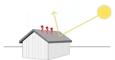
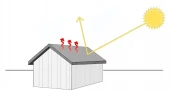
Strategies for Cooling Your Roof During Intense Summer Heat
As summer temperatures soar, the heat can make indoor living conditions uncomfortable, particularly for those living on upper floors. The roof, directly exposed to the sun, plays a significant role in how heat affects the home. However, there are multiple strategies homeowners can implement to keep their roofs and homes cooler during intense heat waves.
Tips to Keep Your Roof Cool During the Scorching Heat of Summer
Selecting Appropriate Roofing Materials
Choosing the right roofing materials is crucial in climates that experience intense summer heat, like Bangladesh. Materials that reflect solar energy rather than absorb it, such as metal, tiles, or specially designed reflective shingles, can significantly reduce heat absorption. These materials help maintain lower roof temperatures, which translates into cooler indoor environments.
Utilizing Cool Roof Coatings
Cool roof coatings are designed to reflect more sunlight and absorb less heat than standard roof surfaces. Applying these coatings can lower roof surface temperature dramatically, reducing heat transferred into the home and prolonging the lifespan of the roofing materials. These reflective coatings are an effective solution for homeowners looking to retrofit existing roofs without complete replacement.
Read more: Tips to Keep Home Cool in Summer Without AC
Enhancing Insulation
Insulation plays a critical role in minimizing heat transfer from the roof to the home's interior. Effective attic or roof space insulation, using materials such as fiberglass, foam board, or cellulose, acts as a thermal barrier. This barrier helps stabilize indoor temperatures, making homes more comfortable during both day and night.
2 years ago

Heatwave forces closure of schools until Thursday
Due to the ongoing severe heatwave, the Ministry of Primary and Mass Education has announced the closure of all government primary schools, child welfare trust schools, and learning centers under the education bureau until Thursday.
Senior Information Officer of the ministry, Mahbubur Rahman Tuhin, signed the notification on Monday, emphasising that the decision was made to ensure the health and safety of children.
Additionally, educational activities at all institutions below the secondary level and vocational educational institutions in Dhaka, Chuadanga, Jashore, Khulna, and Rajshahi districts were suspended for Monday.
Guidelines issued for primary schools reopening tomorrow amid heatwave
A separate notice from the Education Ministry, signed by MA Khayer, public relations officer, was issued on Sunday following consultations with the Health Ministry and the Bangladesh Meteorological Department.
However, educational institutions equipped with air conditioning were allowed to remain open. Despite the ongoing heatwave, which began in the first week of April, schools and colleges had initially resumed classes on Sunday after the Eid-ul-Fitr holidays and their subsequent extension due to the heat.
Primary schools conducted classes on Monday since no directive had been issued by the concerned authorities until Sunday night. This reopening came even though there has been no significant relief from the heatwave, raising concerns among parents, particularly those with young children.
Heat wave: Assembly at all govt primary schools suspended
Originally, schools and colleges were set to reopen on April 21 after the Eid holidays, but the persistent extreme temperatures prompted authorities to extend the closure until April 27. The Ministry has advised parents and guardians to stay informed through official updates as the situation develops.
2 years ago