Island

Silt-borne fertility transforms northern Bangladesh
As floodwaters receded across northern Bangladesh, the newly deposited silt has turned the sandy river islands of the Teesta, Dharla, Saniyazan and Brahmaputra—known locally as chars—into fertile land, sparking a surge in cultivation.
According to the Department of Agricultural Extension, the northern rivers contain nearly 786 char areas and communities living there have begun to rebuild their livelihoods following the recent floods.
Agriculturist Sirajul Islam, Additional Director of the Rangpur agricultural region, says this year’s cultivation target for the chars has been set at 36,911 hectares, with an expected output of 362,000 tonnes of various crops.
“Char residents are likely to recover through this year’s harvest. A single crop can sustain many families for an entire year,” he explains.
A Season of Intense Activity
Across the Teesta’s char zones in Lalmonirhat, Rangpur, Kurigram, Gaibandha and Nilphamari, farmers are working round the clock, Sirajul Islam said.
Read more: Overuse of chemical fertilisers threatens soil health in northern Bangladesh
Large tracts have already been planted with potatoes, aubergines, chillies, onions, ginger, garlic, beans, coriander, carrots, cabbages, radishes, gourds, wheat, sesame, linseed, mustard and maize, he said.
Growers say they anticipate good yields from almost all varieties this season.
In Ichli char of Gangachara, Rangpur, farmer Hossain Mia has planted potatoes on three bighas of land, aubergines on another three bighas and coriander on 20 decimals.
“If the yields are satisfactory, I expect to earn around Tk 1.5 lakh after covering costs,” he said.
Local growers Habibur, Rahim and Khairul echo similar expectations, noting that each of them could make Tk 60,000 to Tk 70,000 in profit if the season is favourable.
Storage and Market Access Remain Major Obstacles
Abdullah Al Hadi, Chairman of Lakshmitari Union Parishad, describes the Teesta’s chars as a “growing agricultural zone”, with fresh produce already reaching local markets.
Many more farmers have begun cultivating again.
Read more: Sand syndicates tighten grip on Bangladesh's northern region
He, however, highlights a persistent challenge: the lack of storage, processing facilities and proper market access.
“This is the biggest frustration for char farmers. Without cold storage, transportation and processing facilities, they are deprived of fair profits,” he said.
He believes the region requires two to three cold storages, while Gangachara currently has only one. Poor connectivity also prevents farmers from transporting goods easily to nearby markets.
Power of Nutrient-Rich Silt
Agriculture officer Tushar Kanti explains that the silt deposited on the Teesta’s chars has made the soil exceptionally fertile.
Many crops are flourishing even without chemical fertilisers. Maize, wheat, potatoes, chillies, onions, garlic, mustard, sesame, linseed and a wide range of vegetables are being grown in abundance, he said.
Read more: Hidden hands in the fields: Dealers blamed for artificial fertiliser shortage in north
Dr Tuhin Wadud, Professor at Begum Rokeya University and a long-time researcher on char lands, says that the post-flood silt left behind on these islands is “extremely fertile”.
As a result, he said, farmers in the region often witness bumper harvests following floods. But he points out that limited transport links continue to hinder farmers from securing fair prices.
He believes dredging the Teesta and other major rivers could bring long-term benefits: “If the rivers were properly excavated, more char lands would emerge, offering northern communities significant economic opportunities.”
Prospects Worth Tk 200 Crore
Agricultural officials estimate that crops from more than 786 char areas across eight northern districts could generate Tk 200 crore in revenue this season.
Field officers from the agricultural department are providing technical assistance and financial incentives, and officials say support has already been extended to char farmers affected by the floods.
Read more: Polyshade tomato farming reviving Narail’s rural economy
6 months ago

Yemeni Island Socotra: The Most Alien-Looking Place On Earth Drawing Global Wanderers
Strange, contorted trees stretch toward a sky so vast it feels unworldly. Bare, jagged cliffs rise from a stark, wind-blasted terrain that seems untouched by time or civilisation. Crystalline waters border bizarre landforms, creating a surreal contrast. Among the world’s many awe-inspiring locations, from Africa’s endless sands to North America’s ancient canyons. Few evoke such profound disbelief as this remote island. Long whispered about in niche travel circles, it now draws increasing global attention. The name? Socotra, locally known as Saqatri. Let’s uncover what's behind this alien-looking island in the Indian Ocean that draws modern explorers.
Geography of Socotra
Tucked between the Guardafui Channel and the Arabian Sea, Socotra forms the largest island in a six-island archipelago. While it falls under Yemen's political boundary, its proximity to Africa gives it a different geographic rhythm. Just 236 miles south of the Arabian Peninsula, this closeness shapes its distinct character.
This remote outpost stands among the most isolated continental landmasses on Earth. It parted ways with the ancient supercontinent of Gondwana millions of years ago. That deep-time isolation shaped its singular environment.
Read more: Chongqing, The 3D City: Chinese Megacity Looking Like AI-Generated
The island is renowned for its extraordinary biodiversity. Many species found here exist nowhere else on the planet, drawing scientific and ecological interest from across the globe. This exceptional natural wealth earned it UNESCO World Heritage status in 2008, marking it as a vital ecological treasure.
Unique Landscape and Discrete Demography
The distinctiveness of this ancient island lies in its terrain, with Socotra shaped over millennia by time, climate, and isolation. Towering limestone plateaus stretch across the island, rising above arid plains and wind-carved dunes. At the heart of it all, a central mountain range climbs to nearly 5,000 feet. It offers an imposing backdrop to an otherwise barren interior. The terrain breaks into elevations that shift with the landscape. Dry mountains and scattered vegetation tell a stark story of nature’s endurance.
This archipelago, over 25 million years old, balances contrasting features- coastal plains brushing against desert stretches, and rocky plateaus giving way to shrub-covered slopes. But what sets Socotra apart is its inimitable biological character. Nearly one-third of its plant species are endemic, including the most iconic locale- the Dragon’s Blood Tree. This umbrella-shaped marvel, known for its crimson resin, casts haunting silhouettes throughout the horizon, lending the landmass its surreal, alien quality.
Read more: Wales’s Stream in the Sky: World’s Tallest Navigable Aqueduct Pontcysyllte
Despite its remoteness, Socotra is home to a modest community of approximately 60,000 people. The Socotrans speak Soqotri, a pre-Arabic language that survives only here. Their cultural fabric, enriched by centuries of isolation, is preserved through an annual poetry competition.
1 year ago

Ultimate Koh Samui Travel Guide: Top Things to See and Do on Thailand’s Stunning Island
Imagine yourself basking under the warm sun on a postcard-perfect island, where palm trees sway gently along powdery beaches, and crystal-clear waters shimmer endlessly. Welcome to Koh Samui, Thailand’s second-largest island and a must-visit tropical paradise that enchants travelers from around the globe.
In this all-in-one Koh Samui travel guide, uncover the island’s hidden gems, explore its cultural landmarks, and find out why this breathtaking destination deserves a top spot on your travel bucket list. Whether it’s relaxing on secluded beaches or visiting ancient temples, your unforgettable Koh Samui adventure starts here!
Location and Naming History
Koh Samui is Thailand’s second-largest island, with a distinct area of 228.7 square kilometres. Situated on the east coast of the country, the island is a place blessed with natural scenic beauty.
In Thai, the word “Ko” means island. However, the origin of the word “Samui” is still unknown. Local people believe that the island got its name from the native tree named Mui. Others associate the Sanskrit-Tamil root “S̄mwy” as the origin, which means “sea weather.”
Read more: Discover Ha Long Bay: Your Ultimate Travel Guide to Vietnam’s Natural Wonder
Koh Samui has always been a great attraction for travellers. According to a 1998 report, the island used to receive around 700,000 visitors. In 2020, that number declined due to COVID-19's global impact. Even so, 2023 has observed a steep increase, measuring over 200,000 annual visitors.
How to Reach Koh Samui
Only two islands in Thailand have international airports; Koh Samui is one of them. Travellers can directly reach the island by air. However, most travellers like to take off in Bangkok or Phuket first and then take a second flight to Koh Samui. It takes about an hour to land in Koh Samui from both airports.
But once you are in Thailand, you can also take a bus and ferry combined route. Many tour agencies and private service runners offer combo tickets. This may require you to change your vehicles multiple times and be a much slower journey; nonetheless, it will make your travel more meaningful by letting you see more of Thailand.
Read more: Ultimate Pattaya Travel Guide: Top Things to See and Do in Thailand’s Coastal Gem
1 year ago

Best Asian Alternatives to the Maldives: Affordable Island Getaways
Nestled serenely within the expanse of the Indian Ocean, the Maldives has lured travelers with its opulent allure. The pristine beaches, crystal-clear waters, and luxurious resorts have made it an icon in high-end travel. Yet, for those with a more budget-conscious spirit, some exotic tourist destinations in the heart of Asia can offer almost similar experiences. Let’s take a look into some of the most popular budget-friendly Asian alternatives to the Maldives.
10 Best Budget-Friendly Alternatives to the Maldives in Asia
Phi Phi Islands, Thailand
This tropical paradise, along with its mesmerizing blend of stone and sand beaches, is located in the Andaman Sea. Among this island group comprising six distinct islands, Phi Phi Don is renowned for its Monkey Beach and Maya Bay.
In the case of spending the night, Tropical Garden Bungalows come with a jungle vibe with modern amenities.
The airfare to Phitsanulok, the nearest airport to this place, from Bangladesh starts at USD 230 (BDT 25,264.65 at an exchange rate of USD 1 = BDT 109.85) per person.
Meals cost approximately THB 417 or BDT 1,289.45 (THB 1 = BDT 3.09) per day, while local transportation is estimated at THB 253 or BDT 782.33 daily.
The average cost for a couple's hotel stay in Koh Phi Phi is THB 2,956 (BDT 9,140.58).
Read more: Beach Bucket List: 9 Magnificent Sea Shores in South Asia
Koh Lipe, Thailand
This hidden gem, located in the Andaman Sea, offers hiking opportunities to take in the island's natural beauty from elevated vantage points. The island provides a variety of amenities, from bars and open-air restaurants to cafes and massage shacks.
2 years ago

Manpura Island Travel Guide: Breathtaking Paradise in Southern Bangladesh
Manpura Before 2009, Manpura was just another island on the southern edge of the Meghna River in the Bay of Bengal. Thanks to Giasuddin Selim’s Magnum Opus “Manpura” movie, the island came into the limelight. Ever since the blockbuster, there has been a growing interest in Manpura as a new travel destination.
Here’s everything you need to know about the Manpura island, how to get there, what are the attractions, and many more.
Where is Manpura island?
Manpura island is situated in the northern Bay of Bengal. It borders the exit of the Meghna River into the bay. The island is formally known as Manpura upazila under the Bhola district. It is surrounded by the two of the biggest islands of Bangladesh – Bhola and Hatia.
Read more: Tinap Saitar Waterfall Travel Guide: Visit a pristine natural fountain in Bandarban
2 years ago
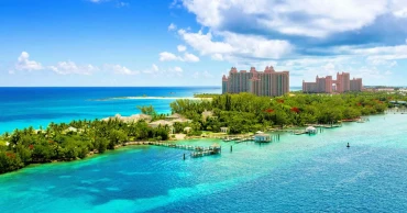
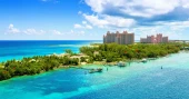
Island Paradise: The Bahamas Travel Guide
Often considered the tropical paradise of the Atlantic, the Bahamas is an archipelago chain consisting of over 700 small islands and cays. The islands offer pristine beaches, serene turquoise water, and a thriving flora and fauna. The Bahamas is known for being the perfect tropical getaway, attracting millions of tourists each year. Let’s look at 10 of the most interesting places to visit and exciting things to do in this Atlantic archipelago.
10 Best Places to Visit in the Bahamas
Nassau
You can start the retreat from the capital of the Bahamas itself, Nassau. Nassau City is known for its history and untainted natural beauty. Almost all major airlines fly into the Lynden Pindling International Airport, located in the heart of Nassau.
Nassau is one of the more crowded destinations in the Bahamas. As a result, the vibrant straw market and the cable beach attract tourists from different countries around the world. From vibrant parties to late-night shenanigans, Nassau has it all. To explore the historic side of things, head over to Fort Charlotte.
Read more: These are the countries you can visit visa-free with a Bangladeshi passport in 2023
Accommodation in Nassau will range between 150 to 400 USD per night, depending on the guesthouse or luxury resort.
3 years ago