California fire

Unhealthy air in California city as massive warehouse fire burns for third day
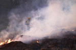
Air quality in a Northern California city has turned unhealthy as firefighters continued for a third day on Saturday to contain a large blaze at a medical equipment warehouse.
Authorities in Tracy, a city of around 100,000 residents, urged people sensitive to smoke to stay indoors as thick smoke spread from the Medline warehouse fire, which has been burning since Thursday. Air monitoring stations in the southern part of the city recorded pollution levels in the “unhealthy” range.
Officials said smoky conditions are likely to continue over the next few days as crews work to fully extinguish the fire inside the massive facility, according to South San Joaquin County Fire Authority Fire Chief Randall Bradley.
Investigators, including the local fire marshal, are examining the cause of the blaze. Fire officials are also coordinating with company representatives and structural engineers to assess damage to the building.
Plans are being made to allow employees to safely retrieve their vehicles from the site. Authorities have urged the public to stay away from the area and warned against touching or moving debris.
Medline, the company operating the warehouse, is a major supplier of medical and surgical products, including gloves, masks and surgical instruments.
The fire broke out at the nearly 1 million-square-foot warehouse, located about 55 miles (88.5 kilometres) east of San Francisco, sending embers across a wide area.
Firefighters said their efforts were hampered by malfunctioning sprinklers and hydrants with little or no water flow. They believe the problem lies within the facility’s internal fire-suppression system, not the city’s water supply.
Officials added that an external inspection of the sprinkler system in January had found no problems.
1 month ago

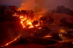
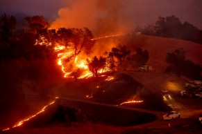
Delayed emergency alerts failed Los Angeles residents during wildfires
Government emergency alert systems are designed with a simple purpose: to provide residents with critical information about nearby hazards and safety instructions, reports AP.
However, as seen in the devastating Los Angeles wildfires and other emergencies, these alerts depend on a complex communication chain involving first responders, government officials, third-party companies, and the public.
At times, this system fails.
When powerful winds ignited wildfires in Southern California on Jan. 7, evacuation orders for certain neighbourhoods—particularly the part of Altadena where most fatalities occurred—were issued long after houses had already caught fire. On Tuesday, Los Angeles County officials authorised an external review of the alert system’s performance during the Eaton Fire and Palisades Fire in response to residents’ concerns. City authorities refused to answer AP’s inquiries about delays in some Palisades Fire alerts, though Fire Captain Branden Silverman noted that assessing a fire and determining evacuation protocols can take time.
Progress made on huge fire north of Los Angeles while new fires erupt in Southern California
This problem is increasingly common. After-action reports and investigations have identified failures in alert systems in other major fires: the 2017 Tubbs Fire, which claimed 22 lives in Santa Rosa; the 2018 Camp Fire, which resulted in 85 deaths in Paradise; the Woolsey Fire, which broke out the same day and killed three in Malibu; Colorado’s 2021 Marshall Fire, which destroyed over 1,000 homes near Denver; and Hawaii’s 2023 Lahaina Fire, which devastated the historic town and killed 102 people.
It may take months to determine why some evacuation orders were delayed during the Los Angeles wildfires.
Several residents who lost their homes in the Eaton Fire told The Associated Press they never received any notifications about their area. For others, the first warning came as a frantic text message in the middle of the night.
Susan Lee Streets, who had registered for the Nixle alert app, did not receive any alerts specific to her West Altadena neighbourhood before she and her family evacuated on their own around 10 p.m. after losing power and mobile service.
“If we had been informed that houses and other structures were burning, we would have understood the gravity of the situation,” she said. “We almost went to bed that night with two kids, a dog, and two cats in the house.”
Her phone finally received an alert after 3 a.m. By then, her home—and irreplaceable family heirlooms, including her children’s Christmas ornaments—had been reduced to ashes.
“We lost everything. Absolutely everything,” Streets said, her voice breaking.
Tricia Wachtendorf, director of the Disaster Research Center at the University of Delaware, emphasised that alerts must be clear and specific. Research has shown that for alerts to be effective, people must hear, understand, believe, personalise, and confirm them before taking action.
“Sending a message at 3 a.m. doesn’t guarantee that someone will hear it,” Wachtendorf said.
The period between midnight and 3:30 a.m. was particularly difficult for first responders in Los Angeles County, according to an AP review of scanner traffic recordings and data from CalFire, FEMA, and the Watch Duty app.
Resources were stretched thin, and hurricane-force winds had grounded aerial firefighting support, making it harder for authorities to assess the fire’s spread from above.
Emergency calls reporting burning homes flooded in as embers ignited rooftops and gardens. During a 30-minute window, firefighters were dispatched to 17 new addresses while some crews ran dangerously low on fuel.
By 12:07 a.m., CalFire records showed that dozens of neighbourhoods east of Altadena’s North Lake Avenue had been ordered to evacuate due to the Eaton Fire. However, no warnings had been issued for the western areas—where all 17 confirmed fatalities occurred—even though house fires had been reported there more than an hour earlier, as first reported by the Los Angeles Times.
Over the next three hours, firefighters shifted from requesting reinforcements for the eastern edge of the fire to urgently notifying command that the flames were spreading west along the foothills near Sunset Ridge.
At 3:30 a.m., evacuation orders were significantly expanded, with residents in 12 Altadena neighbourhoods and beyond told to “leave now.”
Jodi and Jeff Moreno first learned about the fire from a neighbourhood app. The first official warning they received came around 2:30 a.m., when authorities shouted through a bullhorn instructing them to evacuate. They quickly gathered their three daughters, their dog, and essential documents before fleeing.
They received no text alerts until after they had left.
“On the neighbourhood apps, some people were leaving, while others were staying. There was a wide range of responses. We had to figure things out on our own,” Jodi Moreno said. “It was hard to determine exactly where the fire was and where embers were landing… That’s the kind of information we expect from authorities.”
Desperate for updates, both the Morenos and Streets downloaded the Watch Duty app, which consolidates evacuation maps and real-time information from multiple sources. Since launching in 2021, the app has expanded to cover 22 states and became an essential tool for many residents.
“The best warning system is one that actually informs people,” said Nick Russell, vice president of operations at Watch Duty.
Over 50,000 under evacuation orders or warnings as wildfire imperils homes north of Los Angeles
“There is a necessary process in issuing official evacuation warnings, orders, or shelter-in-place instructions,” he added. “But transparency is key—people need to understand why those discussions are happening between law enforcement and fire officials. That’s what we provide.”
The process of issuing evacuation orders begins when firefighters or other personnel on the ground recommend action, Russell explained. The decision then moves up the chain of command until the sheriff’s office officially issues an order.
During major emergencies, communication can be hindered by factors like poor radio signals, wind noise, or technical issues. Incident command centres may struggle to process vast amounts of data from different agencies, making it difficult to grasp the full scope of a disaster like a wildfire.
In Los Angeles County, residents who sign up for emergency alerts through the AlertLACounty website are directed to a list of 57 links to local or city-specific alert systems, along with a general one covering 19 cities. The city of Los Angeles and the Sheriff's Department also operate their own alert services.
It remains unclear how these overlapping systems, which use different software, integrate with each other—or whether officials coordinate their alerts effectively.
A 2024 Hazard Mitigation Plan instructed the city’s Emergency Management Department to identify gaps in alert systems in areas with poor mobile coverage and implement a solution. However, this objective was assigned only a “medium” priority and a long-term timeline, with completion expected within the next decade.
Meanwhile, the county’s Hazard Mitigation Plan—last updated in 2020—did not prioritise emergency alerts or public notifications. Instead, its primary objectives focused on educating residents about how wind increases wildfire risk and improving community wildfire protection efforts.
Officials at the County’s Coordinated Joint Information Center declined to comment, stating only that an independent review of evacuations and emergency notifications is planned. The Office of Emergency Management, County Fire Department, and Sheriff’s Department have committed to fully participating in the review.
1 year ago
.jpg)
Nearly 900 buildings destroyed by massive California fire
California’s largest single wildfire in recorded history kept pushing through forestlands on Tuesday as fire crews tried to protect rural communities from flames that have destroyed hundreds of homes.
Clear skies over parts of the month-old Dixie Fire have allowed aircraft to rejoin nearly 6,000 firefighters in the attack this week.
“Whether or not we can fly depends very much on where the smoke is. There’s still some areas where it’s just too smoky,” fire spokesman Edwin Zuniga said.
Heavy smoke reduced visibility on the fire’s west end while the east end saw renewed action as afternoon winds took hold, fire officials said.
Read: Wildfires in Algeria leave 42 dead, including 25 soldiers
Burning through bone-dry trees, brush and grass, the fire by Tuesday had destroyed more than 1,000 buildings, including nearly 550 homes. Much of the small community of Greenville was incinerated during an explosive run of flames last week.
But the reports are “definitely subject to change” because assessment teams still can’t get into many areas to count what burned, Zuniga said.
The Dixie Fire, named for the road where it started, also threatened 14,000 buildings in more than a dozen small mountain and rural communities in the northern Sierra Nevada.
Crews have cut thousands of acres of new fire lines aimed at preventing the fire from spreading. Officials believe the fire lines created on the blaze’s southern side will hold the fire at bay there, but the fire’s future is unknown, authorities said.
“We don’t know where this fire is going to end and where it’s going to land. It continues to challenge us,” said Chris Carlton, supervisor for Plumas National Forest.
Temperatures are expected to rise and the humidity is expected to fall over the next few days, with triple-digit high temperatures possible later in the week along with a return of strong afternoon winds, fire meteorologist Rich Thompson warned Monday evening.
Read: Wildfires rampage in Greek forests, cut large island in half
The fire that broke out July 14 grew slightly on Tuesday to an area of 766 square miles (1,984 square kilometers) but containment increased to 27%, according to the California Department of Forestry and Fire Protection.
The Dixie Fire is about half the size of the August Complex, a series of lightning-caused 2020 fires across seven counties that were fought together and that state officials consider California’s largest wildfire overall.
Gov. Gavin Newsom on Tuesday declared a state of emergency for northern Shasta, Trinity and Tehama counties. The declaration frees up state resources to help fight fires in those counties and give assistance to residents affected by he blazes.
California’s raging wildfires are among some 100 large blazes burning across 15 states, mostly in the West, where historic drought conditions have left lands parched and ripe for ignition.
The Dixie Fire is the largest single fire in California history and the largest currently burning in the U.S. Nearly a quarter of all firefighters assigned to Western fires are fighting California blazes, said Rocky Oplinger, an incident commander.
Heat waves and historic drought tied to climate change have made wildfires harder to fight in the American West. Scientists have said climate change has made the region much warmer and drier in the past 30 years and will continue to make the weather more extreme and wildfires more frequent and destructive. The fires across the West come as parts of Europe are also fighting large blazes spurred by tinder-dry conditions.
Read: Thousands flee homes outside Athens as heat fuels wildfires
In southeastern Montana, the small towns of Ashland and Lame Deer were ordered evacuated Tuesday as a wildfire threatened hundreds of homes outside the Northern Cheyenne Indian Reservation. Rosebud County Sheriff Allen Fulton said flames were being driven by strong, erratic winds.
“We’re actually pretty worried about it,” Fulton said. “It’s jumping highways, it’s jumping streams. A paved road is about a good a fire line as we could ask for, and it’s going over that in spots.”
Northwest of the Dixie Fire in the Shasta-Trinity National Forest, hundreds of homes remained threatened by two fires. However, nearly 50% of the McFarland Fire was contained. New evacuation orders were issued Monday for residents near the Monument Fire, which was only about 3% contained.
South of the Dixie Fire, firefighters prevented further growth of the River Fire, which broke out last Wednesday near the community of Colfax and destroyed 68 homes. It was nearly 80% contained.
4 years ago

California fire prompts evacuations; Oregon blaze balloons
A rapidly growing wildfire south of Lake Tahoe jumped a highway, prompting more evacuation orders and the cancellation of an extreme bike ride through the Sierra Nevada on Saturday as critically dangerous wildfire weather loomed in the coming days.
The Tamarack Fire, which was sparked by lightning on July 4, exploded overnight and was over 32 square miles (82 square kilometers) as of Saturday evening, according to the Humboldt-Toiyabe National Forest. The blaze was threatening Markleeville, a small town close to the California-Nevada state line. It has destroyed at least three structures, authorities said, and was burning toward the Alpine County Airport after jumping a highway.
A notice posted on the 103-mile (165-kilometer) Death Ride’s website said several communities in the area had been evacuated and ordered all riders to clear the area. The fire left thousands of bikers and spectators stranded in the small town and racing to get out.
Kelli Pennington and her family were camping near the town Friday so her husband could participate in his ninth ride when they were told to leave. They had been watching smoke develop over the course of the day, but were caught off guard by the fire’s quick spread.
Read: Fires threaten Indigenous lands in desiccated Northwest
“It happened so fast,” Pennington said. “We left our tents, hammock and some foods, but we got most of our things, shoved our two kids in the car and left.”
Saturday’s ride was supposed to mark the 40th Death Ride, which attracts thousands of cyclists to the region each year to ride through three mountain passes in the so-called California Alps. It was canceled last year during the coronavirus outbreak.
Paul Burgess, who drove from Los Angeles to participate in the ride, said most of the cyclists he met were thankful to steer clear of the fire danger.
“They just said this is just how it goes,” Burgess said. “It’s part of climate change to a certain extent, it’s part of just a lot of fuels that are not burnt, the humidity is low, the fuel moisture levels are low, and ... around the state, many parts of it are much like a tinderbox.”
Afternoon winds blowing at 20 to 30 mph (32 to 48 kph) fanned the flames as they chewed through bone-dry timber and brush. Meteorologists predicted critically dangerous fire weather through at least Monday in both California and southern Oregon, where the largest wildfire in the U.S. continued to race through bone-dry forests.
The Bootleg Fire grew significantly overnight Saturday as dry and windy conditions took hold in the area, but containment of the inferno more than tripled as firefighters began to gain more control along its western flank. The fire was still burning rapidly and dangerously along its southern and eastern flanks, however, and authorities expanded evacuations in a largely rural area of lakes and wildlife refuges.
The fire is now 439 square miles (1,137 square kilometers) in size, or more than 100 square miles larger than the area of New York City.
“This fire is large and moving so fast, every day it progresses 4 to 5 miles,” said Incident Commander Joe Hassel. “One of the many challenges that our firefighters face every day is working in new country that can present new hazards all the time.”
Read:Western wildfires threatening American Indian tribal lands
Extremely dry conditions and heat waves tied to climate change have swept the region, making wildfires harder to fight. Climate change has made the West much warmer and drier in the past 30 years and will continue to make weather more extreme and wildfires more frequent and destructive.
In southern Oregon, fire crews have dealt with dangerous and extreme fire conditions, including massive “fire clouds” that rise up to 6 miles (10 kilometers) above the blaze. The Bootleg Fire has destroyed at least 67 homes and 117 outbuildings.
The conflagration has forced 2,000 people to evacuate and is threatening 5,000 buildings, including homes and smaller structures in a rural area just north of the California border.
The Tamarack Fire sent heavy smoke over Lake Tahoe and into Nevada.
The National Weather Service warned of possible thunderstorms stretching from the California coast to northern Montana on Sunday and that “new lightning ignitions” are likely because of extremely dry fuels across the West.
Firefighters said in July they were facing conditions more typical of late summer or fall.
The fires were just two of numerous fires burning across the drought-stricken U.S. West, as new fires popped up or grew rapidly in Oregon and California.
There were 70 active large fires and complexes of multiple fires that have burned nearly 1,659 square miles (4,297 square kilometers) in the U.S., the National Interagency Fire Center said. The U.S. Forest Service said at least 16 major fires were burning in the Pacific Northwest alone.
A fire in the mountains of northeast Oregon was also growing rapidly and was 17 square miles (44 square kilometers) in size on Saturday. The Elbow Creek fire started Thursday and has prompted evacuations in several small, rural communities around the Grande Ronde River about 30 miles (50 kilometers) southeast of Walla Walla, Washington.
Read:Wildfires threaten homes, land across 10 Western states
Oregon Gov. Kate Brown invoked the Emergency Conflagration Act to mobilize more firefighters and equipment to help fight that fire.
The Dixie Fire, near the 2018 site of the deadliest fire in the U.S. in recent memory, was 5% contained and covered 39 square miles Saturday. The fire was in the Feather River Canyon, northeast of the town of Paradise, California, and survivors of that horrific fire that killed 85 people watched warily as the new blaze burned.
Officials ordered the evacuation of a wilderness recreation area and kept in place a warning for residents of the tiny communities of Pulga and east Concow to be ready to leave.
“We’re prepared,” said Mike Garappo, a retired military veteran. “We’ve dealt with fires living in the mountains forever. We know there’s a chance it may not hit here, but we’re ready to go in case.”
5 years ago
.jpg)
Californians see power shutoffs as winds, fire danger rise
Hundreds of thousands of Californians lost power as utilities sought to prevent the chance of their equipment sparking wildfires and the fire-weary state braced for a new bout of dry, windy weather.
More than 1 mill
5 years ago

California nears milestone: 4 million acres burned in fires
California is poised to hit a fearsome milestone: 4 million acres (1.6 million hectares) burned this year by wildfires that have killed 31 people and incinerated hundreds of homes in what is already the worst fire season on record.
5 years ago

Northern California wildfire leaves 3 dead
Three people died in a wind-whipped Northern California wildfire that has forced thousands of people from their homes while carving a 25-mile path of destruction through mountainous terrain and parched foothills, authorities said Wednesday.
5 years ago

California fire: Record 2 million acres burned
Wildfires have burned a record 2 million acres in California this year, the US Forest Service said.
5 years ago

Not out of woods yet, but winds driving California fires die
Calmer weather allowed crews to increase containment on wildfires after a three-week siege of gusts fanned blazes across California and led utilities to cut power to prevent winds from blowing branches into electric lines and igniting an inferno.
6 years ago
Utilities say equipment probably sparked California fires
Los Angeles, 30 Oct (AP/UNB) — Electrical equipment caused two Southern California wildfires — one that killed three people and destroyed more than 1,600 homes last year — and another still smoldering in the well-heeled hills of Los Angeles, where thousands of people including Arnold Schwarzenegger fled homes in the dark, utilities said Tuesday.
6 years ago